Site - header
Traffic modeler Pilsen
Traffic Modeller for Pilsen
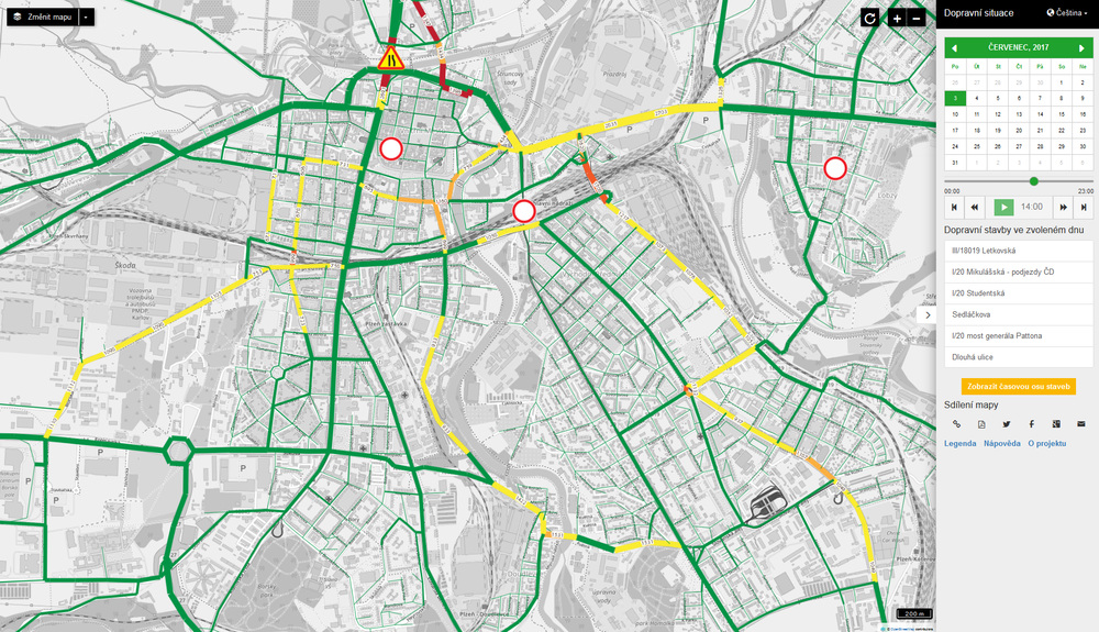
The application displays the expected traffic situation in Pilsen in one hour intervals during the period from May 2017 to November 2018. The traffic volume information is derived from the city’s traffic model and takes into account ongoing roadworks on the selected day.
The web map application was developed by Plan4all for the City of Pilsen. The map application is available at https://intenzitadopravy.plzen.eu/.

Traffic Modeler (TraMod) is a tool for transport modeling developed in collaboration between traffic engineers, IT and GIS specialist. It can be fully implemented in server environment with an application programming interface (API) for mobile and web applications. This creates an opportunity for a city or a region government representatives to test various traffic scenarios within seconds without a need to install and learn how to use desktop traffic modelling software or contacting traffic engineers every time a new roadwork appears in the region.
How does it work?
TraMod is a server based solution for regional traffic modeling that allows city or a region planners to change various network parameters (see Key Features) and see the effects of those changes in traffic flow in near real-time. This is made possible by TraMod’s API.
This allows developers to integrate TraMod into their web/mobile application or to use a web client based on HSLayers framework.
This solution is currently being developed for a pilot area of interest – the city of Pilsen. With a Traffic Modeler Application (TraMod App) city planners will be able to plan long term road closures as well as prepare for short but significant changes in traffic flow such as an important sport/culture event in a city. A TraMod App will also allow sharing and publication of designed traffic models.
Key features
(implemented/planned)
- Calculation of traffic volumes in a transport network in near real-time (depending on the size of the road network and server capacity calculation the time may vary from seconds to minutes).
- Implementation of three algorithms for the traffic assignment providing optimal calculation schema for every use case.
- Calculation a what-if analysis with user-defined scenarios which may include:
- edit of road free-flow speed
- edit of road capacity: e.g., road/lane closure
- edit of road segment geometry: e.g., change of intersection layout
- addition of a new road segment: e.g., construction of a new city ring road
- edit of traffic generators: e.g. consideration of the new census data
- addition of new traffic generators: e.g. special cultural event or newly built city mall
- Using TraMod Web App Calculated traffic scenarios including proposed edits in traffic network/generators can be saved and shared.
What data do you need?
To use TraMod in your use case you need a few input datasets:
Traffic network that is topologically correct and contains traffic attributes necessary for traffic volume calculation. Mandatory attributes include: road capacity, free flow road speed and allowed intersection directions (”turns”). TraMod is ready to be implemented for bidirectional and unidirectional road networks.
Traffic generators linked to the traffic network: Traffic generators are zones that model traffic attractivity in the network. Examples of traffic generators are: housing city blocks, schools, office buildings, malls etc.
Origin-destination matrix or matrices for different vehicle types and/or time periods.
Traffic census on road network neuralgic points (used for calibration of the model).
Architecture
An initial basic traffic model is calculated in the traditional way by traffic engineers that possess in depth knowledge about the area of interested (demography, road network, traffic census) or it can be calculated by TraMod (then calibration needs to be run as well).
A client/server solution (see Figure 1) then :
Interactively gather user input (road closures, new road planning, etc.) via HSlayers based GUI.
Generate alternative traffic models in near real-time (secs/mins) and portray it in a web client.

Figure 1. Architecture of components for interactive traffic modeling
